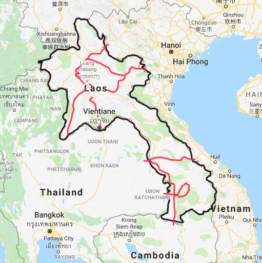
Overview
Since Laos is rated our #1 biking destination our trips here have become numerous. Here is a quick reverse chronological overview.
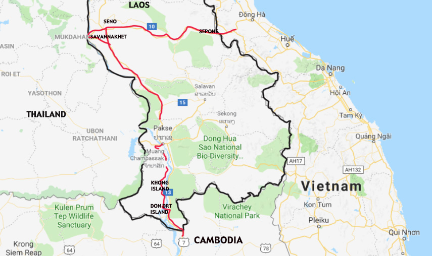
In February, 2018,we entered Laos from Vietnam east of Savannnaket to ride south to Cambodia.
In January, 2017, we entered from Cambodia and rode north to Pakse and the border to Thailand. We rode north and reentered Laos at Vientien, rode to Loung Phabang and crossed into northern Vietnam near Dien Bien Phu.
In January, 2015, we crossed through Laos from Vietnam (Lao Bao) to Thailand from Savannakhat.
Laos 2012, we returned to Laos via Dien Bien Phu, Vietnam. We repeated one of our favorite rides: Luang Prabang to Vang Vieng round trip. Laos is still the best place to bike! It’s been discovered. It is the crossroads for intrepid long distance tourers, traveling from Europe to Southeast Asia or vice versa.
Laos 2010, we returned to Laos via Cambodia in the south. Rode north to Pakse, then cut through Thailand to Vientien and rode north to Luang Prabang and back to northwest Thailand via Houei Sai.
In March 2009 we entered Southern Laos on Hwy #9 from Vietnam and left by Hwy #13 to Cambodia. All was very simple and straight forward.
Also trips in 2002, 2000, 1999 and 1995.
Laos is Thailand 20 years ago, and as we continue to search for the best biking in the world, our appreciation grows for this destination.
Our favorite ride is from Vientiane north to Luang Prabang. In the north there are improved roads which are quiet and pass through dramatic scenery and culturally rich hill tribe areas. Luang Prabang, the ancient capital, is a pleasant small city where you can easily spend several days. From Vang Vieng to Luang Prabang is strenuous mountain riding with outstanding views. North of Luang Prabang the hills are less strenuous. The biking around Vientiane and the surrounding territory is good and the biking around Luang Prabang and north is excellent. Separating these two cities is a mountain range that presents the benefits of sweeping vistas, the villages of Hmong and quiet roads. This mountain range also offers many and often long climbs. You are either ascending or descending.
You can enter Laos from Nong Khai, Thailand via the Friendship bridge across the Mekong river into Vientiane or from Vietnam from the east though the mountains or from southwest China through Yunan province or from northern Thailand across from Chiang Khong, Thailand into Ban Houay Sai by ferry across the Mekong or from Eastern Thailand into Savannakhet across the Mekong by ferry or from Ubon Ratchathani across the Japanese bridge to Pakse.The dry season coincides with the European and North American winter and the climate is approximately the same as Thailand’s. The roads are safe due mostly to the lack of traffic.
Laos is a friendly and honest place with adequate (for a developing country) infrastructure, i.e. roads, hotels, etc. As a pure travel destination, Laos is gaining popularity for good reason.
The backpackers have arrived in droves.
How We Rate This Trip
Roads: 8
1,000 Islands, Mali Guesthouse, on Khong Island
2018 – update. Good roads become bad roads and bad roads become good roads.
The main road between Vientiane and Luang Prabang was newly improved in 1999. 20 years later its older but still ok. It is well engineered with manageable grades. North of Luang Prabang to Highway 1, the road is equally as good. Highway 1, which runs east and west in northern Laos is also improved. Highway 7, which runs to the Plain of Jars, is newly improved. Highway 2, the Old China Road, is old and broken in may spots. The main highway 13 south of Vientiane is also good and recently upgraded. South of Pakse there are good roads including to the Bolevans Plateau.
Traffic: 9
Even in Vientiane, the traffic is manageable. In Luang Prabang, it is a pleasure to ride around the area. Once out of Vientiane on either Highway 10 or 13, the roads become quiet and there are very few trucks. North from Vang Vieng the roads are downright sleepy. Highway 13 from Pakse all the way to the Mekong Islands is quiet. Also, the roads in the Bolevans are tranquil. That being said the traffic levels have doubled in the last 5 years.
Weather: 8
2014, Vang Viang to Kasi, one of our favorite rides
2018- Update. 3 rain showers in March cleared the smokey, hazy, air for a few days.
Hot in March in the south but some rain help cool it down and at night it cooled off a bit and cleared the air.
The seasons are very well defined and the dry and cool season falls from November to April. This is good since it coincides with European/North American winter. During the dry season, the temperatures are warm during the day. In the early morning, in the north, there is fog and cool until the sun burns it off. At night, in the highlands, it can get downright cold. The smoky haze of the burning season, in March/Apri resulted in our lowering this score.
Winds: 8
2018 – Update. Less predictable in late March.
In March the winds were very fickle. They can change even within a day but its surprising how calm the winds are during the dry season. In fact, a little wind in the valleys of the highlands might help disperse the early morning fog. But it doesn’t. Often the winds are dead calm.
Scenery: 8
Riding out of Vieng Viang
2018-Update. Smoke and haze are even thicker.
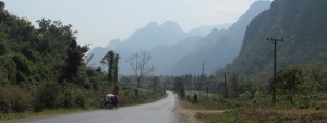
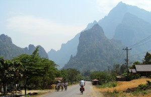
There is geological diversity. The plains around Vientiane are interesting. The highlands offer constant vistas. The far north offers a combination of the plains and highlands. The highlight is around Vang Vieng where the limestone karsts are gorgeous. Highway 13 cuts through this area for about 30 Ks and the riding is easy and the views sensational. The south is less interesting except for the Bolevans Plateau.
Information: 7
2018 Update. Mostly from cyclist heading in the opposite direction. Good source.
In 2002, Lonely Planet published a book, Cycling Vietnam, Laos & Cambodia and a map Thailand, Vietnam, Laos & Cambodia Road Atlas, Lonely Planet. (These were not available during our first trips in 1998, and 2001.) Now they are no longer available. but now there is a motorcycle map by GT-Rider Guide Maps for Laos PDR. There are a lot more well informed Tour guides who will share information with you. Also, guest house operators and NGO’s are very helpful. The state of the roads is ever changing.
Road Safety: 8
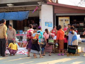
Market Day in , a mountain top town outside of Louang Prabang
2018 Update. More traffic that still uses the same random system that results in more accidents.
Not only are the drivers both slow and courteous, but also the roads have such little traffic that there are seldom any safety issues. This is one of the greatest advantages of Laos over the rest of Asia where the traffic can be chaotic. Even in Vientiane, the traffic is only of modest volume.
General Safety: 9
To walk at night in Vientiane or Luang Prabang, there is only a little risk of crime. Obviously, you must be aware of circumstances around you but it is safe. Crime wise, the small cities and the countryside are very safe and peaceful. The potential for political conflict in the highlands has ameliorated. Previously we were warned of possible problems but we encountered none nor did any other travelers we encountered report any problems even around the Plain of Jars, it is now calm and safe.
Value: 7
The Laotian currency, the Kip, floats freely and generally moves in lock step with the Thai Bhat. Even in Vientiane, hotels, food and drink, and transportation are very reasonable. Nice hotels and restaurants in Vang Vien and Luang Phabang are as cheap as in Thailand. In the smaller towns where you would stay in guest houses and eat in noodle shops, the prices are cheap but the quality is lower. Generally, prices of accommodation have doubled in the last few years.
Fluids: 9
2018 – Update. Now everything is available and cold.
Cold drinks from refrigerators are available in March 2009.
Don’t trust the tap water. Potable water is only available in liter plastic bottles. The cost is cheap and it is available anywhere. Beer Lao is excellent and usually cold. pure ice is usually available. Lao coffee is very good.
Food: 8
Day river boat trip from Pak Mung to Oudomxay, beautiful scenery and village life
2018 – Update. More and better restaurants.
The Lao are Thai “wannabes.” And that is good concerning food. The Major cities are French influenced. You can get baguettes but freshness is an issue. In the countryside the food is basic; sometimes there are only noodle shops. In tourist areas, Indian restaurants have arisen.
Accomodations: 6
2018 – Update. More are available, even in smaller towns.
Like the food, the hotels and Inns in the bigger cities are good and you can find any standard and style you like. In Vang Vieng, new guesthouses are constantly being built. In the countryside, guesthouses can be limited and basic. Often, its hard to reach from guesthouse to guesthouse in the highlands without extra effort or planning.
People: 8
The Lao live in the lowlands and valleys. They are friendly and helpful. Their religion, Buddhism, is very much a part of their everyday existence. The highlands of the north are populated by the Hmong who are tough independent tribesmen. They are very curious about foreigners on bikes. These are laid back people who are never aggressive and easy to be among.
Culture: 7
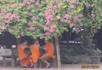
Young Monks in Luang Prabang
2018 – Update. Tribal villages are modernizing. Electricity begets TV, begets Western influence.
The western influence on Laos is growing. The present day pop culture influence is small even compared to the French colonial influence in the major cities. Baguettes are available but McDonald’s hasn’t arrived. Buddhism is omnipresent; you are constantly encountering monks and temples. In the highlands, the Hmong culture is strong and intact. Their cloths, houses, and festivals are vibrantly colorful. But its changing. TVs are every where and its influence is overwhelming. Just seeing the hill tribe boys with moused hair is too much.
History: 5
As in most of Asia, the physical evidence of history is negligible. Most historic buildings are temples and watts. In Vientiane and to some extent in Luang Prabang, the recent history of the French colonial era is still intact. Outside of these cities there is virtually no visible sense of history.
TOTAL SCORE 115
Route Descriptions and Maps
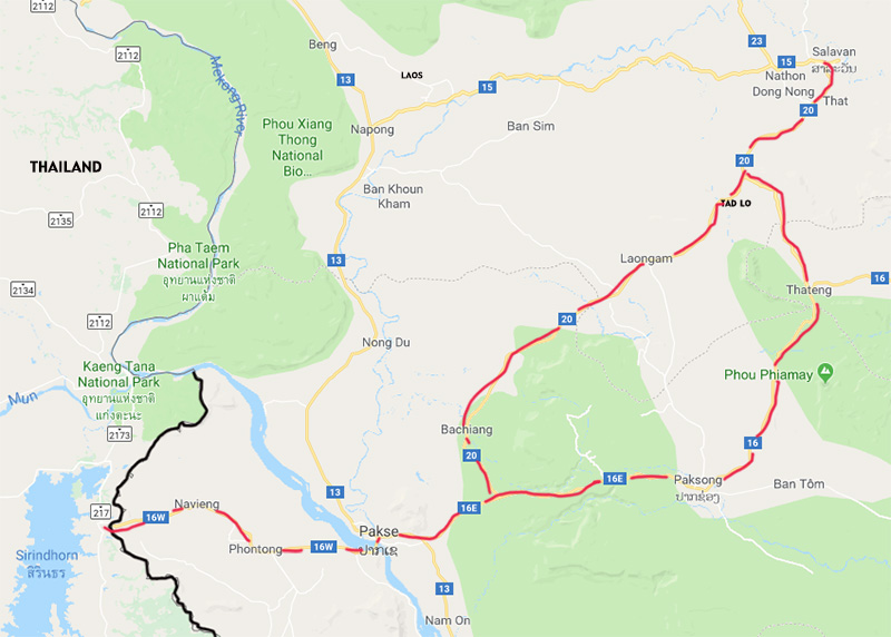
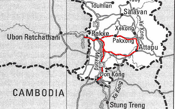
Southern Laos
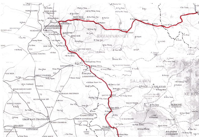
Vietnam Border (Lao Bao) to Cambodian Border, 2009, 2015 & 2018
Vietnam border at Lao Bao to Sepone, Laos 45Ks
Update 2/2018: Excellent, quiet road. Strong tail wind makes it fast riding. Finally sun and warm.
Rolling hills through low mountains. 2-lane. Very good road with a drop down shoulder. Quiet. Dull scenery. Some big trucks. Head winds (west). Sepone at 45Ks.
Sepone to Maung Phin 35Ks
Update 2/2018: This road is a little older and a bit broken. At 25Ks, the road is being resurfaced to 30Ks, then a good road. Strong tailwinds. Maung Phil has many guesthouses.
Flatter, hazy mountain views almost eerie. Road good but patched. Quiet road. Early tail wind then head wind, fluky. Subsistence farming area. Maung Phin 35Ks.
Moung Phin to Dong Hene 94Ks
Update 2/2018: Update: New road to 11Ks, then frequent gravel patches to 25Ks then better older road. At 45Ks, construction. At 48Ks, good new road. Strong NE wind, mostly tail. More traffic and trucks.
(Guest houses at 15Ks, Phahan at 58Ks,basic guest houses before and after town. At 89Ks, 5Ks before Dong Hene (Donghen), a good but isolated guest house, also new guest house 4Ks toward Seno, also isolated.)
Hwy #9 is slightly rolling and straight. Dull scenery. AM tail wind then the winds swirl from all directions. Road is starting to deteriorate (3/2009). Light traffic, some big trucks. Into Dong Hene at 94Ks. (No guesthouses between these two towns.)
Dong Hene to Seno (turn for Pakse) 35Ks**
Update 2/2018: Update: New road to 10Ks, then older road but ok. Again, strong NE tail winds.
Easy rolling or flat into Seno at 35Ks. AM trail wind (light). Dull scenery. Light traffic but more into Seno. Good road, occasionally a little broken.
**Seno Junction Hwy # 9 & 13 (west) to Savannakhet 30Ks, (south) to Pakse 230Ks, (north) to Vientiene 440Ks.
SENO TO SEVANNAKHET 35Ks, (Seno to Paksong, see below)
Update 2/2018: Busy into Sevannakhet.
Easy rolling, 2 lanes with cycle shoulder, moderate traffic, follow winds. At 32Ks, circle. Straight (right, north to bridge, 3Ks. Now, only way to Thailand)
SAVANNAKET TO THAI BORDER, 5Ks to Bridge
Savannaket to Paksong 76Ks
2/2018: Out SE on Hwy #9. OK tar road. Moderate traffic. Rolling. Cross (head) winds (NE). Junction Hwy #13 at 35Ks. Easy rolling. Cross winds. OK road.
Seno to Paksong 64Ks
On Hwy #13 south. Good wide 2-lane tar road. Easy rolling. Light traffic. Viariable winds mostly following. At 23Ks, junction, road from Savanakhet. Greener with nice big trees here. Nice. More rolling after 35Ks. Less scenic. At 62Ks, Paksong
Paksong to Khong Sedone 104Ks
Update 2/2018: Hwy #13. The same after 40Ks, some hills. Dull scenery. Winds start from east (head) in AM then in PM switch all around. Often tail winds. Into Khong Sedone at 104Ks. Nothing special.
Khong Sedone to Pakse 64Ks
Update 2/2018: Tail, N, winds. Moderate traffic. At 55 Ks, 6-lanes with bicycle lane into town.
Hwy 13. The same flat. Nice green rice fields and distant mountains. AM head winds. After 20Ks, more rolling. More traffic into Pakse. Across the 1-lane bridge into town 64Ks.
Pakse to Champasak 39Ks, (New Route 44Ks, less traffic and good scenery)
Update 2/18: 44Ks, Out over bride (toward Thailand) 4 Ks. After toll booth at 8Ks, left. Strong south winds in AM. 2-lanes. Light traffic. Good road. At 41Ks, left into town and river at 44Ks.
Hwy #13 out of town. At 2Ks, the turn for bridge over Mekong and Thailand. Straight. Slightly climbing. At 8Ks, junction. Straight to Bolevans. Right to Kong Island (120Ks). Right on Hwy #13, At 9Ks, end of gradual climb and end of urban sprawl and new highway to Paksong. Rain then head winds then tail winds. At 15Ks, good road drifts lower. Light traffic. Finally, the country side. OK scenery. At 31Ks, right on tar 2-lane road with a few potholes. Up a little then down a little to ferry at 36Ks. Off ferry and 3Ks into Champasak at 39Ks.
Champasak to Vat Phou 20Ks roundtrip
10Ks out and 10Ks back, flat, nice ride.
Champasak to Kong Island 105Ks (New Route 102Ks)
Update 2/2018: 102Ks On the west side of the river. 7Ks, paved then dirt road. Rough (better on a mountain bike). The road improves little by little. Some bridges (rickety) and a short ferry. Right along the river. Pretty. Mostly populated. The road after 50Ks, smooth dirt and a little paved (with pot holes). At 89Ks, at power lines left to ferry to Dong Khong. Off and left on good gravel road to Muong Khong at 102Ks. ***We tried this in 2005 and encountered many obstacles, no bridges and very rough. We made it but it was difficult.***
8Ks back to Hwy #13. Right. Good tar road, wide 2-lanes. Rolling then mostly flat till 80Ks. Then rolling again. Winds from all directions but mostly head winds. Light traffic but moves fast. Dull and redundant scenery. At 104Ks, right on 1-lane tar road to “Kong Island” At 105Ks, the ferry landing. Small boats to the island. The landing is in the center of the hotels.
Around Khong Island 37Ks.
Khong Island to the border with Cambodia 38Ks
3Ks south to Big Ferry then 5Ks to Hwy at 8Ks, right on Hwy #13 the same. At 28ks, road to Ban Nakassang and ferry to Don Det. Straight. At 32Ks, turn for boat to see Dolphins (in 6Ks). Border at 38Ks
Khong Island to Don Det 19Ks
2/2018: Via the islands and ferries along the river. Past the new bridge to ferry at 5Ks. Over, out and left on dirt path on Don Som. Hard but bumpy. Stay near the river (we screwed up and went inland, eventually getting back on the route at the river). At 19Ks, ferry to Don Det.
Don Det to Cambodian Border 19Ks
Update: 2/2018: No change.
Cambodian border to Pakse 2002 & 2010 (Original route on Hwy #13)
Cambodian border to Don Det (Nakasang) 19Ks
Hwy. #13 to 16Ks. Left to Ferry at 19Ks. Gentle winds. Flat, dull. Quiet. Update: 1/17 No change. At 16Ks, left 3Ks, patched and bumpy.
Don Det (Nakasang) to Don Khong 22Ks
Update: 1/17 Out to Hwy #13 for 3Ks, left. At 13Ks, left to bridge at 19Ks. Then right on patched road to Kong at 22Ks.
Out to Hwy. #13 at 3Ks, left for Don Khong. AM winds from south (tail) in February. Stay on Hwy. #13. At 17Ks, road for passenger and bike ferry to Don Khong. Ferry at 18Ks. The ferry lands in the center of the hotels in Don Khong.
Don Khong to Champasak 105Ks
**(See description below in opposite direction from a previous trip 2002. Notes directly below are additions from our 2010 trip.)
1K to Hwy. 13, left. Rolling then mostly flat and rolling again. In February gentle winds but mostly at our backs. Light traffic but fast moving. Dull and redundant scenery. At 97Ks, left. Ferry at 102Ks. Into Champasak from 103 to 106Ks.
Champasak Don Kong Island 105Ks
8Ks back to Hwy #13. Right. Good tar road, wide 2-lanes. Rolling then mostly flat till 80Ks. Then rolling again. Winds from all directions but mostly head winds. Light traffic but moves fast. Dull and redundant scenery. At 104Ks, right on 1-lane tar road to “Kong Island” At 105Ks, the ferry landing. Small boats to the island. The landing is in the center of the hotels.
Champasak to Vat Phou 20Ks roundtrip
10Ks out and 10Ks back, flat, nice ride.
Champasak to Pakse 39Ks
**(See description below in opposite direction from a previous trip 2002. Notes directly below are additions from our 2010 trip.)
Out to Hwy. 13 6Ks, right. Winds from south in February 2010. Pakse at 37Ks.
Pakse to Champasak 39Ks
Hwy #13 out of town. At 2Ks, the turn for bridge over Mekong and Thailand. Straight. Slightly climbing. At 8Ks, junction. Straight to Bolevans. Right to Kong Island (120Ks). Right on Hwy #13, At 9Ks, end of gradual climb and end of urban sprawl and new highway to Paksong. Rain then head winds then tail winds. At 15Ks, good road drifts lower. Light traffic. Finally, the country side. OK scenery. At 31Ks, right on tar 2-lane road with a few potholes. Up a little then down a little to ferry at 36Ks. Off ferry and 3Ks into Champasak at 39Ks.
Update:2/17, Dong Khong to Pakse. Good road. Last 15Ks, rougher and busier.
Bolevans Circle Route 2010
Pakse to Paksong 53Ks
**(See description below from a previous trip 2002. Notes directly below are additions from our 2010 trip.)
Out on Hwy. #13, south. Wide 2-lanes, urban to junction Hwy. #23 at 8Ks, straight. Climbing. Traffic dies down but its fairly busy to junction for Salavan at 21Ks. At 39Ks, dirt road to Tad Fane (in 1K off road to see waterfall and resort). continue up to Paksong at 51Ks, 1300 meters.
**Hwy. #23 is shown as Hwy. 16 on road signs.
We stayed at Tad Fan Waterfall in 2002. Beautiful jungle resort and we were the only guests. Paksong is nothing special.
Paksong to Salavan 84Ks
**(See description below from a previous trip 2002. Notes directly below are additions from our 2010 trip.)
Straight through town on Hwy.#23. Now rolling down on a good 2-lane Hwy. Little traffic. Nice scenery. At 37Ks, Tha Teng. At 40Ks, start of new road (scheduled to be finished July 2010.) First 10 Ks are rolling then down steeper. Good scenery here. Junction at 58Ks. Right to Salavan. Gradual grades mostly down . Good quiet road. Nice villages. Salavan is spread out, center at 84Ks.
**Roads are now paved in this area to Kekong and to Attapu from Salavan.
Paksong to Tad Lo 60 Ks
Per Lonely Planet, continue on Highway #23 to Muang Tha Teng on a scenic good road. (We did not take the back road recommended by LP because we liked Highway #23). 18 Ks before Ban Beng, the road turns into dirt and dust; however, there was no traffic. At T junction you can go right to Salavan or left to Tad Lo. There is a sign for Tad Lo after 4 Ks to left. This side road is about 2 Ks to many guesthouses on a nice waterfall and loaded with backpackers.
Salavan to Tad Lo 33Ks
Gently climbing to junction of Hwy. #23 at 26Ks. Winds gentle and variable in February 2010. Rolling to turn for Tad Lo at 31Ks. Left for 2Ks. Tad Lo at 33Ks.
Tad Lo to Pakse 86Ks
to Hwy. #20 2Ks, right. Start climbing. Moderate grades. At times steep. Then gradually climb from 7Ks to 11Ks. Now, generally gradually descending. Occasional short climbs. Road still quiet. Gentle winds (head). Only OK scenery. After 40Ks, rolling hills and nice scenery. Basic villages. At 50Ks, two bigger hills then gradually climb, steeper before the Junction at 66Ks. Right. Gradual down. At 78Ks, Junction Hwy. #23. At 86Ks, center of Pakse
Pakse to Thai Border 45Ks
Over bridge at 4Ks. Slightly rolling. Wide 2-lane road. Light traffic. Gentle variable winds. Dull scenery. Thai Border at 45Ks. Update: 2/17, 4-lanes all the way.
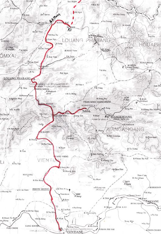
Thai Border (Vientiane) to Vietnam Border (North) 2017 & 2012
Thai Border (Friendship Bridge near Nong Khai) to Vientiane 20Ks
Update: 2/17, the same. The bridge is narrow. From Border out and right. 4-lanes. Moderate traffic. At 13Ks, traffic circle, bear right. At 18Ks, its a one way road. At 20Ks, the center. Vientiane to Vang Sang 62Ks**
In 2012, this road had deteriorated, very dusty and repairs we set to start in late 2012.
Out past airport at 5Ks on Hwy.#13. Previously, we had take Hwy.#10, better) Urban sprawl to 15Ks. Slightly climbing. Moderate traffic on a wide 2-lane tar road. A little bumpy on the edges. North (head) light winds. Green areas are pleasant. Guest houses along the way. Some rolling hills, mostly up. At 62Ks, Vang Sang.**
**We understood that this guest house was at 80Ks but it was at 62Ks, so it was a short day. There are several basic guest houses in Hin Hoeup, 32Ks farther up the road. Update: 2/17, Hwy 13, broken in spots. A 4x traffic factor. We could not find Vang Sang* so stayed in Hin Hoeup at 93Ks.
Vang Sang to Vang Vieng 94Ks**
Update: 2/17, Hin Hoeup to Vang Vieng 60Ks, Hwy 13, being patched poorly, the old road is smoother. 4x traffic increase. **We were told that Hwy 10 from Vientien to Vang Vieng via the lake is the better bike route.In 2012, this road had deteriorated and repairs were set to start in late 2012.
Hwy.#13 Hilly to Phon Hong at 8Ks. Junction with Hwy.#10, straight. Flat. Good scenery. Good 2-lane road. Light traffic. North(head) light winds. At 20Ks, a 2K moderate climb then down a little to a valley. Easy rolling to Hinheup at 32Ks (Guest houses). Ups and downs, twists and turns to 45Ks. Then road mellows out. At 63Ks, easy along river. At 70Ks, Huay Mo, a long busy town. At 73Ks, gradual climb to 76Ks. Variable light winds. Rolling generally gradually down. At 83Ks., flat and straight. At 92Ks, first turn for Vang Vieng, left. Two scenic quiet Ks into town at 94Ks. Update:2/17, Hwy 13, being patched poorly.
Vang Vieng to Kasi, 60Ks
Update: 2/17, Road taring especially near Vang Vieng. After 10Ks, the road is quieter.In 2012, road repairs were were underway near Vang Vieng. More traffic.
Out to Hwy. #13 at 1Ks. Wide 2-lane road. Mostly good condition. Occasionally patched. Less traffic. Great scenery of Limestone Karst mountains. Rolling gradually up. North (head) light winds. In PM variable. At 18Ks, Patang. Over bridge over river. Now gradually up valley. At 28Ks, moderately climb with some steep short ups. Top at 36Ks. Down gradually. A few minor ups but generally down. Easy riding. Kasi at 60Ks. Variable winds.
Kasi to Phoukhoun 45Ks
In 2012, road is older, patched and a little broken but still OK. We rode both ways and going down from Phoukhoun to Kasi was simply a scenic easy ride. More traffic, south winds and because of a night rain great visibility.
Gradually climb thru a beautiful green valley to 7Ks., then climb. Mostly moderate, short steep parts and occasional short downs. At 13Ks, rolling transverse then a steep descent for 2Ks. to bridge at 21Ks. Excellent scenery. Gusty winds (tail). Quiet, good road. Moderate climb to 27Ks. A 1K reprieve then up again. You can see the top now. At 35Ks, view point restaurant but still not the top. At 36Ks, the top. Rolling easy riding then down. Great views. At 41Ks, moderate climb to 44Ks then down into Phoukhoun at 45Ks. Update: 2/17, Some road resurfacing. New surface is rougher (bigger gravel). Winds at back.
****Phoukhoun to Phon Sawon (Xian Hoang) via M Soui 136Ks, toward plain of Jars
A new road. Very curvy and hilly. We started thinking it was 98Ks but the road signs indicated it was 136Ks. This was enough to turn us back. We got two varying reports. The first was that there was a loop all the way back to Luang Prabang. That’s what we intended to do. But a motorcycle guide said that it was a rough road except in and out of Phon Sawan. We did not want to go in and out the same road.
Phoukhoun to Kiewkacham 51Ks.
Update: 2/17, Road has deteriorated. Potholes and gravel sections (never long). Quiet road but now more trucks. Still good biking.Older rougher road. In 2012, only the part of the road north of Phoukhoun for 6Ks is often broken (bottom of the first hill). Vistas but in March obscured by smoke. At 10Ks, road improves. Interesting minority villages. A circuitous route. Great biking. Here is how it goes: up to 1K, down to 7K, up to 11K, rolling to 21K, down to 30K (some steep), up to 38Ks (some gradual),Rolling up and down to 46K (gradual), up to 50K, down to 51K and Kiewkacham.
**Phoukhoun has 2 or 3 adequate guest houses. Kiewkachan has 2 or 3 basic guest houses.
Kiewkacham to Xiengnceun 55Ku
Update: 2/17, More trucks. Old road is smother (a few potholes). New surfacing is rougher and dusty during construction (only for short distances).
Up 1K then down for 22Ks, moderately to 23Ks. Bridge then up. Moderate gradual grades up. Never steep but always climbing to 38Ks. Dowm Good road. Light traffic. To 39Ks then climb to 41Ks. Down twists and turns,OK to town at 54Ks.
Xiengnceun to Luang Prabang 25Ks
Update: 2/17, at 11Ks, by pass road takes all the heavy traffic so quieter into town. Fun ride.
Down along river to 7Ks then away from river, rolling up then moderately climb to 15Ks. Still light traffic, good road and good scenery. Steeper toward the top. Rolling down gradually all the way. More traffic as you go. downtown at 25Ks.
Update: 3/17, Laung Prabang Day Trip to Kuang Si Falls 30Ks
(60Ks round trip) Good ride out along Mekong River. At 5Ks, right (follow signs) up to 7Ks then rolling down to 26Ks. Left up to Falls at 30Ks.
Luang Prabang to Pak Muang 111Ks
In 2012, good road. Out to single lane motorcycle bridge over Nam Khan river at 1K. At 2Ks., left on Hwy.#13. Busy for 8Ks, then quiet. Rolling. At 15Ks, along the Mekong. Good 2-lane road. North (head) winds. At 21Ks, the road to the caves. More rolling hills. At 32Ks, cross the Nam Ou, then following it up river. Very good scenery. Mostly easy rolling hills. 3Ks up to 68Ks then down to 72Ks and up a tributary river. Rolling. At 83Ks, cross this river and now gradually up a pretty, green rice valley. Gradual climb to 95Ks. Then rolling to Pak Muang at 111Ks and Junction. Update: 3/17, The usual sections of construction. 2x traffic factor. Trucks too. Old road smother with same avoidable potholes and new road rougher tar. Still good biking.
Pak Muang to Nong Khiew 30Ks
At junction right on Hwy.#1, narrow, a bit broken 2-lane road, quiet. Rolling down a river valley. Great scenery. Occasional hills. Bridge in Nong Khiew at 30Ks. (see below for Oudomzay to Pak Muang in 2012) Update: 3/17, Older road has plenty of pot holes. Some big. New road rougher tar. Good biking.
Nong Khiew to Vieng Kham – day ride 96Ks round trip.
Hwy.#1, narrow older but OK road. Very quiet. Hilly generally up stream to 14Ks, beautiful then good scenery. Climb moderately (sometimes steeper) to 26Ks. Variable winds. Now down moderate/steep through hill tribe villages. Long vistas. Some hills down into Vieng Khan at Seng River, 48Ks.
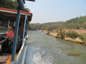
Nong Khiew to Muang Khua via boat. Red dashes are the boat ride.
Muang Khua to Vietnam Border (in reverse)
Vietnam Border to Muang Mai 28Ks
Update: 3/19, Good road. A few pot holes.
Update: 3/17, Good 2-lane road, no shoulder. Quiet.When sealed, it will be a great mountain road. Good scenery. Variable wind.
This road is under construction and they tell us it will be finished by June 2013. Vietnam border to Passport control down gradual 3Ks. Then steep. At 10Ks, gradual descent to river at 18Ks down river valley then 2K moderate climb and down into Muang Mai at 28Ks.
Muang Mai to Muang Khua 40Ks
Update: 3/19, Good road. Open the 4th bridge across the Mekongat 36Ks and 38Ks to town.
Start climbing. At 5Ks steep. Good hazey vistas. At 15Ks, moderate climbing. Up and down to 20Ks, up steep to 22Ks (top). Better road (still under construction) At 30Ks, sealed section to 35Ks to river. Rolling hills up river. Rough sections and a stream ford. The Tug ferry at 40Ks, Muang Khua. Tough trip. When sealed, it will still be a hard ride up for 20Ks. Update: 3/2017, Good 2-lane road.
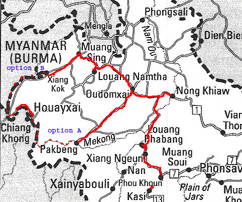
Muang Khua to Thai Border ( Houei Xai) 2017 & 2012
Muang Khua to Oudomxai (Muiang Xay) 100Ks.
Update: 3/19, Older road. Some avoidable pot holes. Some short dirt patches (Dusty). More big trucks but still good. Road unpaved after Muang La.
Update: 3/2017, Short stretches of dirt road. Still a quiet road. After Muang La, road older, a few avoidable potholes. Variable winds. Fog in Early AM.
Out on Hwy.#2E along Pak river. Easy rolling. Nice scenery. Good, quiet tar road. At 72Ks, Muang La (after bridge restaurants and guest house). No wind. Now up a wider valley. More of a climb to 81Ks. Hills away from the river then back to the river (which is now getting puny). Again hilly. After 91Ks, more down than up. At 100Ks, Oudomxay.
Oudomxai to Pak Mung 83Ks (going back toward Luang Prabang)
Update: 3/2017, Now a new road. Light traffic but big trucks. There’s even a cycle lane for 5Ks at the junction for Pak Beng. No shoulder.Slightly up to turn for Pak Beng at 4Ks, left. Moderate/gradual climb. Older tar road. Lots of rough broken sections. Nice views. At 16Ks, rolling hills then at 21Ks, climb moderate to 26Ks. Top*. Steep down to 32Ks then gradual to 40Ks. Hills then moderate climb to 48Ks. Gradual traverse up to pass at 56Ks. All down, some steep. Occasionally a short rise Pak Mong at 83Ks. Tough ride.
*From Muong Khua to this top is 126K climb. Actually, mostly rolling and easy.
Oudomxay to Nateuy 78Ks
Update: 3/19, Road now broken in spots but ridable. More traffic and more trucks so sometimes a little hairy. New Chineese Hwy or high speed rail being constructed before Nateuy.
In 2012, this road is new. Rolling hills up river valley to 9Ks. 1K up, 1K down. At 14Ks, climb. Excellent road. Light traffic. No shoulder. Moderate grades. Curvy. So-so scenery. Hazy. At 18Ks, traverse. Denuded mountains. At 20Ks, easy rolling hills, generally climbing. Top at 30Ks. Down mostly moderate to 44Ks. Interesting villages. Better scenery. No pattern for winds. Easy up then easy down to Na Mor at 50Ks. (Guest Houses). Rolling then up 2Ks to 65Ks. Through tribal villages. Rolling down to Nateuy and junction at 78Ks. (Guest houses, New one 1K out).
Nateuy to Luang Namtha 37Ks
Update:3/19, Road often broken but ridable, some road repairs going on. Variable winds.
Update: 3/17, Very good road. No shoulder. Some big trucks. Last 9Ks from junction, an older road.
Excellent highway now Wide 2-lane road. Light traffic. At first rolling mostly up hills to 9Ks then stair step descent OK scenery. No wind. At 28Ks, turn for by pass to Houei Xai. Bear right toward Luang Namtha. Now straight and nearly flat to 36Ks. Junction. (Right to Muang Sing) Left 1K to Luang Namtha at 37Ks.
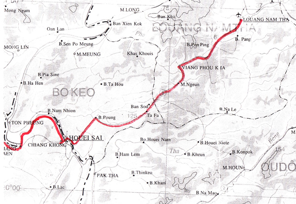
Luang Namtha to Muang Sing 118Ks round trip
Update: 3/17, Older tar road. No road worsening here. Plenty of potholes but on 2 wheels you dance around them. Light traffic. Very few trucks. Good Ride.
Out 1K to junction then straight, rolling hills. Graually up the river on Hwy. #17. Tribe villages. Nice scenery. Today a follow wind (east). Quiet. Older tar road. A little bumpy but OK. At 25Ks, longer, steeper hills. Finally, at 34Ks, a moderate/steep, climb to 37Ks. The top. Moderate/steep down to 40Ks, then rolling hills down a valley. Good scenery. At 50Ks, narrow valley becomes wide and more rolling then a gradual descent to 58Ks, a junction. Right to Muang Sing at 59Ks. (Left at the junction takes you to Xieng Kok where boats are not running to Houei Xai because of low water in the Mekong River 3/2010)
Luang Namtha to Vieng Phukha 61Ks
Update: 3/19, Road is very deteriorated now some construction.
Out to junction with by pass road at 9Ks. Mostly flat. Some traffic out of town then quiet. Rolling gradual climb. A steep 1K climb to 24Ks. 1Ks steep down. Good mountain scenery. Light winds. Very good wide 2-lane road. Rolling down to 30Ks, rolling up to 47Ks, some steep hills, then rolling down to Vieng Phukha at 61Ks. (easy riding)
Vieng Phukha to Ban Don Chai 51Ks
Update: 3/19, Road is good through here. Ban Chai is small. Vieng Phukha is big.
Easy rolling hills up a valley to 13Ks, the dreaded coal mine and now coal trucks. Continue rolling up till 21Ks. Moderate/steep climb to 26Ks. Good scenery. Quiet road but some coal trucks. Rolling down moderately steep to 33Ks. Then a stair step climb to 40Ks. Hazy vistas. Now down moderate/steep. Bottom at 48Ks. Drift lower to Ban Don Chai at 51Ks.
Ban Don Chai to Houei Xai 69Ks
Update: 3/19, Good road Hwy 3. More traffic but good. Sometimes deteriorated. At 64Ks, ??? go directly to Bridge to Thailand 7Ks.
Up 1K steep. Newly completed asphalt road in 2012. Easy rolling to 10Ks. Steep then moderate climb to 13Ks. Down to 16Ks. A short hill and down to 20Ks. Good scenery. Tribal villages. Quiet road. Rolling hills. 3K steep climb to 31Ks. 3K steep descent then rolling to 37Ks. Now its a very gradual down but a few moderate hills up and down. Still little traffic (Sunday). Variable winds. Dull scenery. At the Mekong River at 64Ks. Rolling hills Into Houei Xai at 69Ks. Main road is one-way against us.
Houei Xai to Bridge to Thailand 11Ks
3/19, The new Bridge is completed. At 4Kks, stay right on smaller road directly to Bridge. (Left toward Luang Namtha. Over the bridge by Bus with your bicycle.

This route is in the LP book.
This route is in the LP book.
Louang Phabang to Northern Thai Border or China
Louang Phabang to Pak Mong 111 Ks
This is a relatively easy ride on a well-engineered road. From Louang Phabang, the road generally heads up the Mekong river toward the Pak Mong Caves. There are rolling hills and you cross 2 bridges over rivers running into the Mekong. The traffic is light (as usual) with nice scenery. At 66Ks from Louang Phabang. the road heads inland and initially climbs 3Ks and then stays inland along a river for 28 Ks. Stores and noodle shops occasionally dot the way. Finally, you cross the river and gradually climb up a smaller river. It’s never steep and leads to a broad high valley at the source of the river. Here are rice fields and more population. Highway 13 then drifts lower to the junction with Highway 1, the east-west road in northern Laos.
Pak Mong to Muan Ngog 30 Ks
Highway 1 is older, not as well engineered, hilly and sometimes bumpy. It’s 9 Ks to Nam Bak where there are guesthouses etc. More hills but also some level areas. There is increasingly beautiful scenery. Muan Ngog is 21Ks from Nam Bak. There’s a bridge over the river in Muan Ngog. (Highway 1 is a reasonably good road heading east after the bridge. There are occasional villages and good scenery.)
Muan Ngog to Udon Xai (Sai) 116 Ks
Retrace your route 30Ks to Pak Mong. Out of Pak Mong the older Highway 1 heads up a river valley over rolling hills. Then a continuous 6% Climb for 7 Ks to a Hmong Village which is 22 Ks from Pak Mong. Then up again thru a valley with denuded hills over an older, less engineered, curvy and sometimes rough roads. There is virtually no traffic. Often trees shade the road. Highway 1 continues mostly up and some down through Hmong villages, usually situated on mountaintops. These are very interesting traditional villages which sometimes offer bottled water and snacks. At 30 Ks from Pak Mong at the highest point, the rough road descends for 8 Ks crosses a river and climbs 2 Ks then descends another 8 Ks. There is a village, 37 Ks before Udom Xai at the bottom.
In 2001, this road was being improved. Highway 1 climbs along side a river then mostly descends at 23 Ks before Udon Xai. Another 2 K climb and 2 K descent before the junction at 5 Ks to go. Turn right at the junction on a good road. (Highway 2 goes left at this junction toward Pak Beng)
Option A
Udom Xai to Muang Houn, (toward Pak Beng) 92 Ks
From the city go 5 Ks back to the junction and go straight to Highway 2, the very old road that was known as “The China Road” years ago. This road eventually follows the Beng river valley down to the Mekong river at Pak Beng. In 2001, this road was under construction and difficult. At 13 Ks from Udom Xai, you climb over a ridge for 2 Ks. There is a long 6 K descent then climb over a gradual pass, the headwaters of the Nam Beng. Go down 4 Ks then short climbs and descents. Good scenery through rice fields. In Maung Beng (63 Ks form UX) there’s a basic guesthouse. Continue mostly down to cross the river. Now there’s more population in a broader valley. There is a marker and at 92 Ks, you are in Moung Houn.(see road story)
Moung Houn to Pak Beng 52 Ks
8 Ks from Moung Houn the way becomes hillier and rougher for 20 Ks. At 121 K Marker there is a short descent and the road, which is still broken black top, becomes better. You ride through a beautiful narrow gorge and pass beside the Beng River Forest, as you continue down the right side of the Beng River. It is rough road all the way to Pak Beng. The last few Ks are steeper down to the Mekong River.
There is river transportation from here either direction: back down river to Louang Phabang or up river to Houai Xai where you can cross into Thailand. It’s possible to take bikes on a long tail speedboat up the river in a very short time. We did this on one trip and our long boat carried 4 passengers, (the two of us plus another couple) and our bikes and panniers on a fast, exciting noisy rush up the Mekong. We paid two extra fares for our bikes.
Option B
Udom Xai to Luang Namtha 117 Ks
Staying on Highway 1, the first 15 Ks are good road then the road deteriorates and starts climbing over rolling hills. There are some Hmong villages. At 32 Ks, the road improves and descends. Good scenery. Some patches of improved road but mostly bad and rolling. Toward Luang Namtha, it’s flatter and the road is better through a rice valley.
Luang Namtha to Maung Sing 58 Ks
Some good road especially near Laung Namtha follow up a river gradually. After 27 Ks, there’s an interesting Akka village. Climb up a valley for 9 Ks to the top. The road is sometimes ok and sometimes rough. Good scenery through lush jungle. Then down a valley, which widens out to a rice valley. The road is better for the last 8 Ks after potholes and some gravel.
Side trip
Muang Sing to Chinese Border 11 Ks
Sometimes it’s possible to ride for the day in China. Can’t officially cross. Go gradual up on a rough blacktop road to the border.
Muang Sing to Xiang Kok 70 Ks
In 2001, there’s a new dirt road that was smooth. This road could (will) change. Easy 12 Ks up to a small pass then down along a river. Road is 90% good. Good scenery and villages. More rolling hills for last 30 Ks with light traffic but dusty. Last 10 Ks is a gentle descent to Xiang Kok.
Xieng Kok to Houay Xai (across from Thailand) 4 hour boat ride plus 30Ks by road
We took a long tail boat on the Mekong for one of the most exciting rides of our lives. These small boats take bikes. The trip is 4 hours down river. The boat dock was 30Ks before Houay Xai. There is a new road to town. The road is going to be extended. This is a good ride, quiet with rolling hills along the Mekong.
Road Stories
2012 – Peddle Problems
Unlike ourselves, our bikes are getting older. Arriving in Luang Prabang, Laos, my left clip on pedal was agrinding and acrunching. It’s time for a replacement but there is no such thing as a clip on pedal in Laos. So, I settle on one junk pedal and one operable clip on pedal. On my way to the bike shop, I run into Johnie (Italian) whom I’ld met in Vietnam. It turns out that he rents bikes when he travels but carries his own clip on pedals to replace the local junk pedals. He’s going home tomorrow so he gives me his clip on pedals, he no longer needs them. 2 clip on pedals in a country and I find them. One in a million. Yeah, Yeah, we are getting older but we’re still lucky.
FREE LAUNDRY (MARCH 2009)
We went to Khong Island in southern Laos on the Mekong River. Following a path along the river on our way to a place we vaguely remembered from years before we started past a guesthouse, then stopped. Crisp white paint, neat landscaping with a row of purple orchids in front of the porch was too inviting. The owners were just getting out of their car. Mr said, “low season, $20, with breakfast and free laundry”. Free laundry were the operative words. It was very hot and we were sweaty filthy. Then Mrs. said,”We saw you on the road and wanted to stop but “- she pointed to the open back hatch of the wagon. It was full of small fruit trees. “Come look at a room. You prefer up or down?” I pointed up. “One or two beds?” I held up two fingers. (I wasn’t used to a Lao speaking such good English). She went on as we climbed the stairs, “We couples who have been married a long time prefer two beds.” There was a porch on the second floor with table, chairs and fan. A handsome couple were reading there. “Not like these young love birds who want one bed.” The couple looked up and smiled. The room was perfect, spotless, big, places for stuff, big bathroom, air-con, soft bed (beds here are like rocks) “We’re here” I said. As she showed me the kitchen where we make our own breakfast stocked with everything you can dream to eat in the morning. She told me Nigh will clean the dishes. Then gave me a basket for the laundry. She explained that she, Mali, and her husband, Talor, had immigrated to Ottawa Canada 30 years ago (hence the perfect English). We were both married in 1969. Our intention to stay one night led to three as we fell into a fast friendship with Mali, Talor, the couple from Austria and two girls from Ottawa traveling Asia (who knew Mali in Ottawa). Long breakfasts sharing travel stories, days sightseeing around the island. Then at 6PM Peter would head to the local watering hole. I would go to the kitchen with the Austrian couple and Mali would give us a Laos/Canadian cooking lesson. At 7PM, we would all eat dinner together at a table on the Mekong River under the stars with the perfect breeze and no bugs. Mali was the entertainment. She would regale us with stories of being an immigrant in Canada. We all said you do not act Lao. They are quiet and reserved. Mali said, “Me? I am Chinese and I have a Chinese mind.” Telor had been in the army and was sent for training (in those days) to the US. So when the Communist took over they had to leave Laos. They swam across the Mekong river to Thailand and immigrated to Canada. He can fix anything and opened an office equipment repair shop and she had a restaurant called “The Greasy Spoon.” (This name was very difficult to explain to our Austrian friends). Mali speaks fluent Chinese (3 dialects), Vietnamese, Lao, Thai and English. She never buys any of her 9 children a birthday gift. They give her a gift. “”I gave them life”, she says. “We adopted 2 of the kids from the refugee camp but they are all mine.” Peter asked her where he could get his ripped pannier fixed. She sewed it. She changed our excess Lao Kip back to Dollars. We did not know when we took the room that we would get: equipment repair, money exchange, cooking lessons, complimentary gourmet dinners, nightly entertainment and philosophical insight. All for the same price as the free laundry.
What does basic mean?
The Guest House in Moung Houn had the smallest of signs but we found it. The lady showed us the square room with no furniture. We slept on a floor mat that was rolled up in the corner. But, first things first: a shower or bath. They lady pointed across the road to the river we had been following. This was our bathing room. Private, it was not.
***
On our first trip, in 1995, we had been worried about possible danger in the highlands so we proceeded with our eyes open. At one point 4 AK47 toting tribesmen crossed our path. Overcoming our initial trepidation, we played it cool and tried not to draw their attention to us. At this point, one of the gunmen struck a pose and gesticulated that Sally should take their picture. Continuing to play it cool, she declined. We all moved on.
***
Biking is a quiet sport. I was climbing up another mountain in the highlands when I spotted a Hmong man bathing in the stream/ditch next to the road. This should definitely tell you about the traffic level on the road. In any case, I wasn’t sure how to announce my approach and when I startled the bather, he immediately reached for his pile of clothes. The thing is that he first reached for his long knife to defend himself. As soon as he realized that I presented no challenge to him, he put the knife back and continued his bath. I thought to myself, “This is a tough neighborhood.”
***
Luang Prabang is a really good reason to go to Laos.
It is hard to get to. There is air service or its a long road trip so it does take a commitment to get there. (Perfect for biking.) It offers a peaceful, leafy, culturally interesting and comfortable experience. Also, it offers very interesting fellow travelers.
We chilled for a few days here and from time to time we met other bikers and finally had a sunset gathering looking over the Mekong River with spring rolls and beer. Here was the guest list:
An Englishman who had traveled by bike around Asia for 7 years on and off. We first met him in Vientiane.
A New Zealand couple and their two children, who at the time taught school in Phnom Penh, Cambodia.
Two Australian men who were biking around Luang Prabang on day trips.
An American women who was a bike tour guide in Vietnam: she had rented a one speed bike in Luang Prabang.
Two Australian men who had met the American women previously and also had rented bikes to get around Luang Prabang.
Being overwhelmed by our good fortune to have such a great chance gathering, I, from the heart, said to them, “I should be so lucky to be in the company of such interesting people at home.”
For What It’s Worth
- Weather in the winter (November to March);
- The mornings are foggy and cool until 10AM when the sun finally burns off the fog and starts to heat up the valley.
- The burning season is March and April and the air is heavy with smoke to the point that you can’t see the sun.
- There is river transportation from PakBeng either way: down river to Luang Prabang or up river to Huai Sai (Houay Xai) where you can cross into Thailand.
- With bikes it is possible to take a long tail speed boat up the river in a very short time. Our long tail boat carried 4 passengers (the two us plus another couple) and our bikes with panniers on a fast, exciting noisy rush up the Mekong. We paid two extra fares for our bikes.
- Hwy 2 to PakBeng is actually easier to bike than to drive in a vehicle since with two narrow wheels and better agility you can avoid most of the potholes.
- Here are some distances on Hwy 13:
- Vientiane to Phon Hong 70Ks
- Vientiane to Hin Heup 94Ks
- Vientiane to Narnone 147Ks
- Vientiane to Vang Vieng 156Ks
- Vientiane to Pha Tang 173Ks
- Vientiane to Kasi 213Ks